The West Elbow Communities Local Area Plan (WELAP) is a City of Calgary policy document that guides future growth and change in 16 communities including Altadore, Bankview, Cliff Bungalow, Elbow Park, Erlton, Garrison Woods, Lower Mount Royal, Mission, Rideau Park, Roxboro, Scarboro, South Calgary, Sunalta, Upper Mount Royal, the portion of North Glenmore Park north of Glenmore Trail SW, and the portion of Richmond east of Crowchild Trail SW.

The objective of the WELAP is to develop a growth plan for the combined area of these 16 communities. It is similar to the past area redevelopment plans which the city developed with individual communities. The LAP is much larger in scope involving multiple (in our case 15 other) communities which makes this effort very complex. The result is intended to build on the strengths of individual communities and enhance the interconnectivity and amenities of this 16-community area. It will provide guidance and direction on future development, investment, and community improvement decisions.
The WELAP initiative is driven by the city’s need to prepare for and manage its expected growth over the next 30-years. The goal is to have 50% of new growth placed in the city’s developed areas. Historically, most growth has been in greenfield communities at the edge of the city. The WELAP will recommend where and how additional density should be placed across communities. City planners will refer to the WELAP policies when assessing applications for new development permits and land use re-designations.
One feature of the WELAP includes the development of heritage guidelines for historic communities like Elbow Park. The intent is to enhance the heritage characteristics of these communities which results in restrictions on new development.
The West Elbow Communities Local Area Plan (WELAP) is a statutory document adopted as an Area Redevelopment Plan and approved by bylaw.
The policies and maps in the WELAP are used to help guide decisions about the ongoing evolution of the West Elbow Communities. Residents, landowners, builders and developers, local businesses, city departments, and Councillors can commonly refer to the WELAP when new development ideas and community improvements are proposed and considered within the West Elbow Communities.
The WELAP is comprised of 5 maps which define key aspects of the plan and include the following:
Map 1: Community Context defines the boundaries for the communities included in the plan.
Map 2: Community Characteristics and Attributes defines the infrastructure within the plan area.
Map 3: Urban Form illustrates the general location of urban form categories (which describe the primary community functions and land uses) and how they apply across the unique geography of the Plan area.
Map 4: Building Scale illustrates the general building height and massing within the Plan area, which supports the primary function shown in Map 3.
Map 5: Heritage Guideline Areas defines specific areas that must met Heritage Guidelines.
To understand the type and scale of development that is defined in the Plan area both maps 3 and 4 should be read together. The specifics of each map are outlined below.
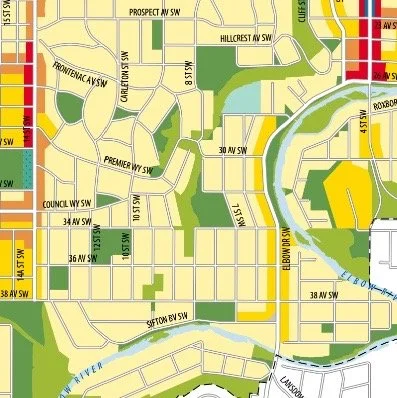

There are several urban form categories that direct land use and built form in the West Elbow Communities. The WELAP defines the characteristics of the urban form categories and where they apply as well as land use, site, building, and landscape design policies for each category.
Each urban form category has general policies associated with it. When an individual urban form category is applied to a specific area of the Plan, the general policies of that category apply in addition to any area specific policies outlined in the Plan.
Map 3: Urban Form
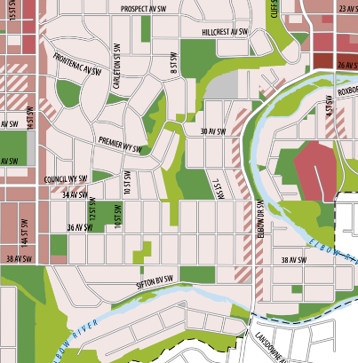

Map 4: Building Scale
Building Scale illustrates the maximum potential height and size buildings can be in a specific area within the West Elbow Communities. Scale Modifiers outline building heights, massing, and other design considerations.
Elbow Park has building scale ranging from “Limited (up to 3 Storeys)” in most areas covering current R-CG zoning to proposed “Low modified (up to 4 Storeys) along Elbow Drive and Council Way and “Low (up to 6 Storeys)” mostly along 14th Street.
Zoning changes to current RC-G zoning to accommodate building scale higher than “Limited (up to 3 Storeys) will require a Public Hearing by City Council although changes will be informed by the WELAP Map 4: Building Scale.
Map 5 : Heritage Guideline Areas
Heritage Guidlines Areas have specific Land-use bylaw requirements for: Site and Landscape Design, Roofs and Massing, Front Façade and Windows, Materials and Details. For specific details and how they apply to Elbow Park please click on button below.